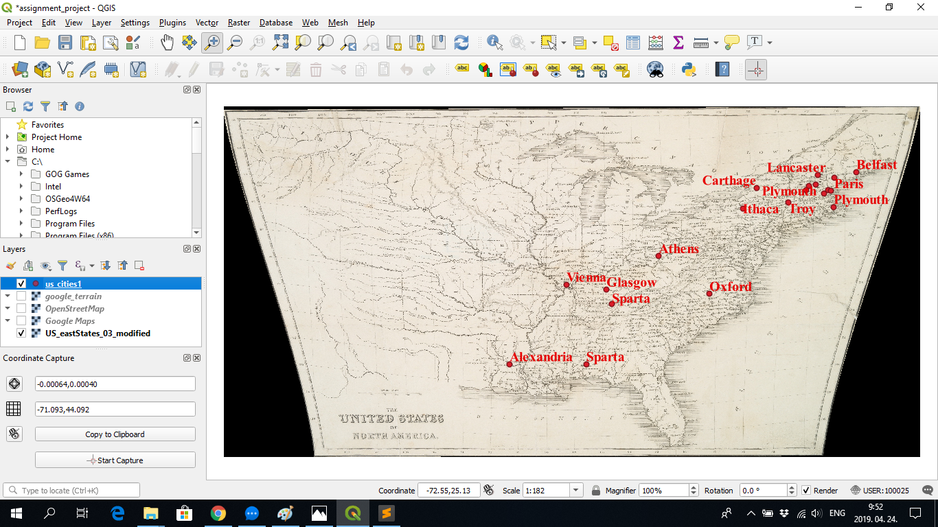
For the georeferencing assignment I used two old maps (one dated to 1843, the other not dated) of the United States. I found it exciting that many cities in the U.S. are actually named after cities in other countries.
For obvious historical reasons, British cities play prominently (Liverpool and Manchester apparently have several twins on the other side of the Atlantic) but there are also many city names of Greek background (Athens, Ithaca, at least two Spartas) and others with origins from countries as diverse as India, Poland and Saudi Arabia (Delhi, at least three Warsaws, Medina). Vienna also has its twin city located in Illinois.
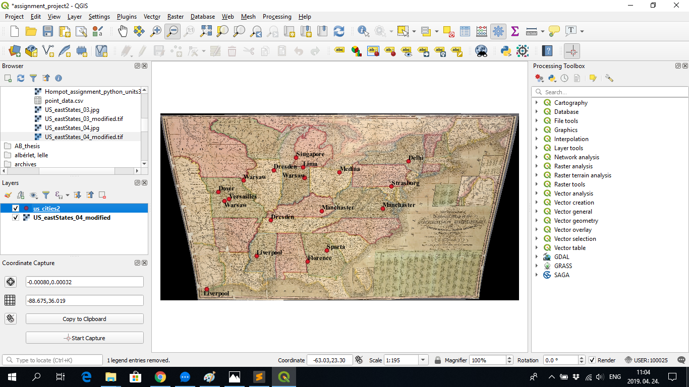
It is also worth mentioning that some cities appearing on these 19th century maps are not inhabited anymore, such as this ghost-town version of Belgrade in Texas, destroyed during the Civil War.
I hereby submit the screenshots and CSV texts of my assignment:
city,state,lon,lat,lon1,lat1
Alexandria, Louisiana, -92.710,30.810,-92.710,30.810
Athens, Ohio, -82.250,38.394,-82.250,38.394
Belfast, Maine, -68.406,44.285,-68.406,44.285
Chester, New Hampshire, -70.648,42.808,-70.648,42.808
Carthage, New York, -75.398,43.183,-75.398,43.183
Dover, New Hampshire, -70.359,43.050,-70.359,43.050
Glasgow, Kentucky, -85.914,36.041,-85.914,36.041
Hanover, Vermont, -71.750,43.308,-71.750,43.308
Ithaca, New York, -76.367,41.738,-76.367,41.738
Lancaster, New Hampshire, -71.093,44.092,-71.093,44.092
Oxford, North Carolina, -78.703,35.738,-78.703,35.738
Paris, Maine, -69.960,43.916,-69.960,43.916
Plymouth, Massachusetts, -69.992,41.840,-69.992,41.840
Plymouth, New Hampshire, -71.226,43.402,-71.226,43.402
Portsmouth, New Hampshire, -70.187,42.957,-70.187,42.957
Sparta, Alabama, -87.335,30.812,-87.335,30.812
Sparta, Tenessee, -85.531,35.047,-85.531,35.047
Troy, New York, -73.179,42.172,-73.179,42.172
Vienna, Illinois, -88.718,36.390,-88.718,36.390
Windsor, New Hampshire, -71.937,43.027,-71.937,43.027
city,state,lon,lat,lon1,lat1
Belgrade, Texas, -95.476,29.178,-95.476,29.178
Delhi, New York, -74.824,42.302,-74.824,42.302
Dover, Missouri, -94.275,39.166,-94.275,39.166
Dresden, Illinois, -88.627,41.406,-88.627,41.406
Dresden, Tennessee, -88.907,36.245,-88.907,36.245
Florence, Georgia, -85.144,32.025,-85.144,32.025
Lima, Indiana, -85.616,41.682,-85.616,41.682
Liverpool, Mississippi, -90.383,32.592,-90.383,32.592
Liverpool, Texas, -95.476,29.178,-95.476,29.178
Manchester, Kentucky, -83.717,37.211,-83.717,37.211
Manchester, Virginia, -77.459,37.470,-77.459,37.470
Medina, Ohio, -81.869,41.169,-81.869,41.169
Montpelier, Indiana, -85.462,40.581,-85.462,40.581
Singapore, Michigan, -86.307,42.683,-86.307,42.683
Sparta, Georgia, -83.188,33.181,-83.188,33.181
Strasburg, Pennsylvania, -76.553,39.716,-76.553,39.716
Versailles, Missouri, -93.195,38.428,-93.195,38.428
Warsaw, Illinois, -91.726,40.328,-91.726,40.328
Warsaw, Indiana, -85.462,40.581,-85.462,40.581
Warsaw, Missouri, -93.686,38.221,-93.686,38.221
Meanwhile, I would also like to point out some issues I came across during completing the assignment.
Since both maps have coordinate systems I did the georeferncing by the manual input of the coordinates in their four corners.
Therefore, a certain degree of inaccuracy can be expected, although based on some double-checking on Google Maps, I do not think it is
beyond 1 degree.
Longitudes on the second map are based on the position of Washington D.C. After checking out the city’s position on Google Maps, I
concluded that the map’s 0° longitude is equal to -77° (West) of the international standard (based on Greenwich, UK). I did the input of
the corner coordinates according to this.
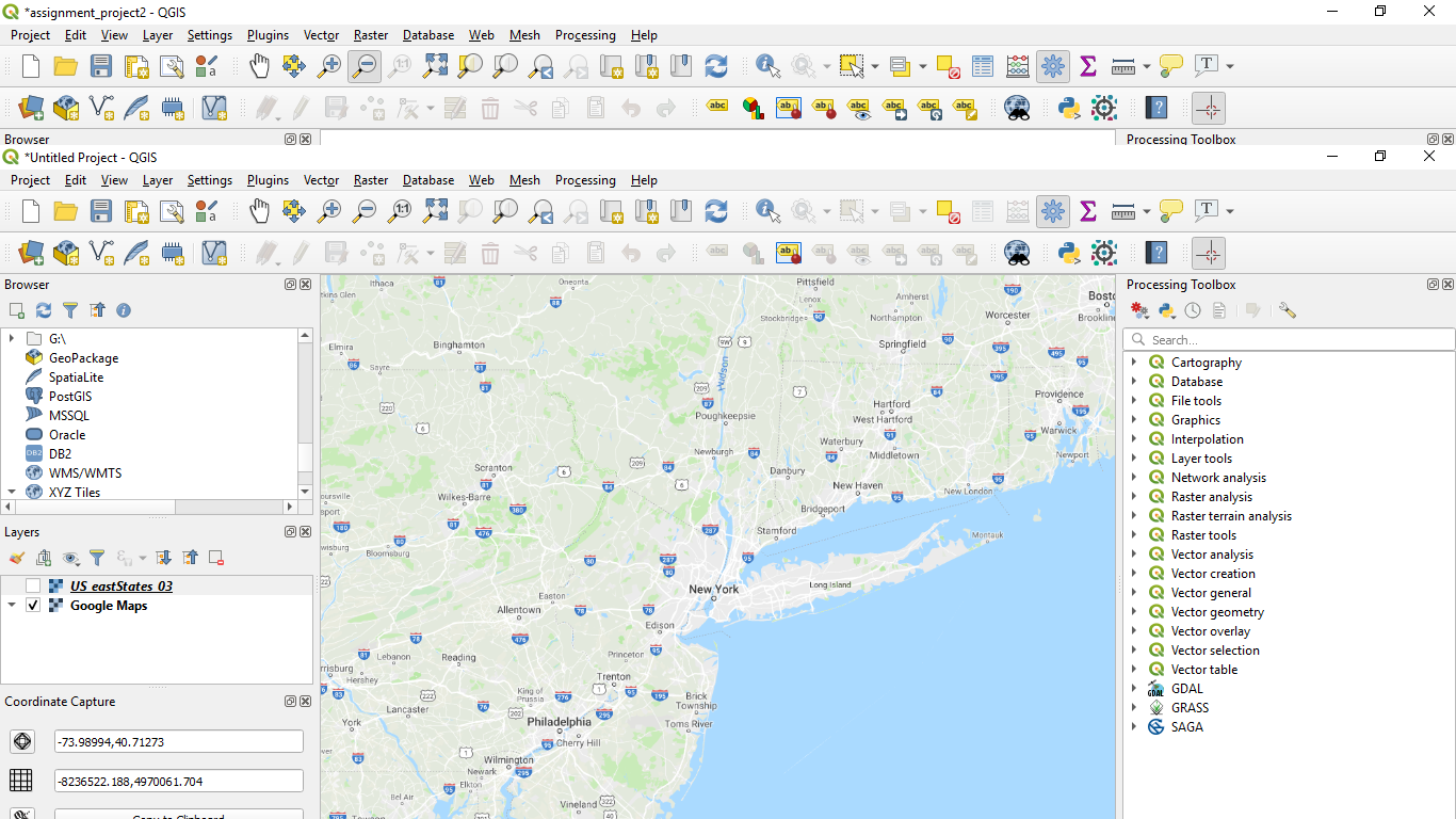
One of the difficulties was that when I added the Google Maps and OpenStreetMaps layers in QGIS, it apparently displays incorrect
coordinates for me. For example, the coordinates of New York City are apparently ca. “-74 West, 41 North” and not “-8234229.297 West, 4970380.761 North” as displayed in the Google Maps layer inside QGIS.
I would also like to note that when opening Google Maps in Chrome, it works with the correct coordinates.
When I tried to connect the layer of the maps used for the project and the Google Maps layer (for using the “From Map Canvas” function
to add coordinates), QGIS displayed both the correct and incorrect coordinates on the left side (under ‘Coordinate Capture’, see attached image below):
However, upon clicking on the point I wished to add, it only captured the incorrect ones (see second image below):
